

| << Chapter < Page | Chapter >> Page > |
You became acquainted with basic map skills in Grade 8 and did exercises that involved the 1:50 000 topographic map of Alice. In doing that, you learned to:
determine location
gauge accurately and determine direction
calculate distance by making use of a scale
explain the naming of a map
recognise conventional map symbols
recognise representation of height on maps
identify contour patterns
This knowledge, together with what you will still be acquiring in using the 1:50 000 topographic map of Bloemfontein and a 1:10 000 orthophoto map of a portion of this will see you through this year’s work.
Before commencing the practical exercises, you have to learn a number of additional map skills.
Calculating distance on an orthophoto map.
Orthophoto maps are always drawn to the scale of 1:10 000. Follow the steps to determine distance:
Accurately measure the distance between two points in centimetres, using a ruler (or using a string if the line to be measured curves);
Convert this distance to kilometres or metres, depending on what is required.
Example
A________________________________B
The length between A and B is 10 cm.
Scale 1 1:10 000
What is the true distance in km?
10 cm x 10 000
100 000 cm ÷ 100 000
1 km
What is the true distance in m?
10 cm x 10 000
100 000 ÷ 100
1000 m
Why do we divide by 100 000 and 100?
The metrical units of measurement can be represented as follows:
| Km | Hm | Dm | M | dm | cm | mm |
| 1 | 0 | 0 | 0 | 0 | 0 | |
| 1 | 0 | 0 |
We therefore have 100 000 cm in 1 km
and
100 cm in 1 meter
You may therefore follow the shorter method if you can remember that the scale of
1 : 10 000 is the same as:
1 cm = 10 000 cm
1 cm = 100 m (÷ 100)
1 cm = 0,1 km (÷ 100 000)
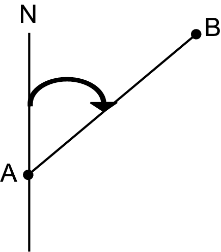
You have learnt how to gauge accurately in Grade 8. Remember the steps that have to be followed:
Connect the two points by means of a pencilled line.
Example:
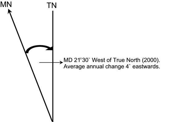
On a map, North therefore indicates the North Pole, which we refer to as TRUE NORTH (geographic north.)
The earth also has a magnetic field that extends from north to south, for which we use a compass. The earth’s magnetic field does not correspond exactly with the true North and South Poles. North as indicated by the compass will always lie WEST of TRUE NORTH (TN) and is known as MAGNETIC NORTH (MN).
The difference between true north and magnetic north is known as the MAGNETIC DECLINATION (MD). The Magnetic Declination differs from place to place and continuously increases and decreases at any place, because magnetic north is not a fixed point.
To make it possible to determine the Magnetic Declination of any place, the following information is given in the margin of a 1:50 000 topographic map:
Example:
Calculate magnetic declination as at present:
Step 1:
Calculate the difference in years = 2003 – 2000
= 3 years
Step 2:
Multiply the years by the annual difference in minutes = 3 years x 4'
= 12'
Step 3:
Determine whether the angle increases (eastwards) or decreases (westwards).
Eastwards (smaller) -

Westwards (bigger) +
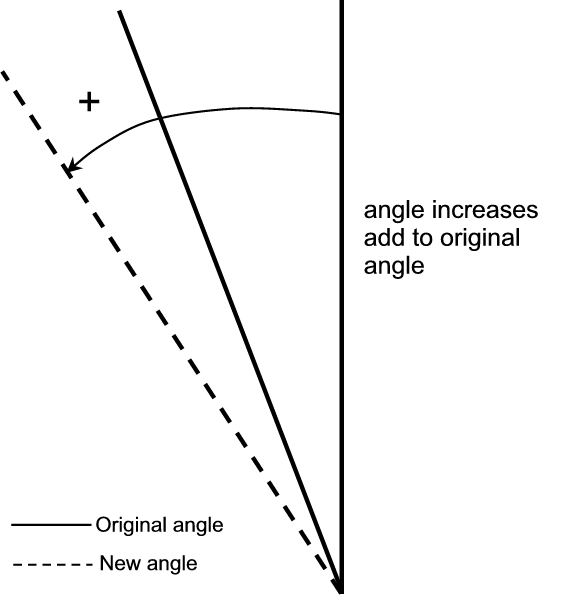
Step 4:
Add the minutes (westwards) or subtract them (eastwards).
In this instance it is eastwards, therefore:
21°30' - 12'
= 21°18' West of True North
REMEMBER that there are 60' in 1°.
If you should have to subtract and find that the degrees to be subtracted are too many, you “borrow” 1° and convert it to minutes.
Example:
21°30' – 34'
20°90' - 34'
= 20°56' West of True North.
If you should have to add minutes and get an answer that is more than 60’, you have to convert it 1°.
Example:
21°30' + 34'
21°64'
= 22°04' West of True North.
Step 5:
Remember to write West of True North alongside the new declination, because Magnetic North ALWAYS lies WEST of True NORTH.
Magnetic North
To gauge Magnetic North between two points, the degrees of TRUE NORTH must be added (+) to the Magnetic Declination and the answer must be written in degrees:
Example:
TN + MD = MN
50° + 21°18' = 71°18'
| Learning Outcomes(LOs) |
| LO 1 |
| Geographical EnquiryThe learner will be able to use enquiry skills to investigate geographical and environmental concepts and processes. |
| Assessment Standards(ASs) |
| We know this when the learner: |
| 1.2 asks questions that are relevant for identifying sources; |
| 1.3 draws conclusions and makes analyses to obtain information from sources such as photographs, maps, atlases, graphs and statistics; |
| 1.4 correlates information from different sources; |
| 1.7 reports on knowledge that they have obtained through research, making use of different sources of information. |
| LO 2 |
| Geographical Knowledge and UnderstandingThe learner will be able to demonstrate geographical and environmental knowledge and understanding. |
| We know this when the learner: |
| 2.2 identifies ways in which Science and Technology have contributed a positively and negatively influence to development (people and resources.) |
ACTIVITY1:
ACTIVITY2:
1. True North / Bearing :
Magnetic Declination:
1990 – 2003 = 13 years
13 × 2’ = 26’ westwards
18 0 41’ + 26’ (westwards)
= 18 0 67’
= 19 0 07 west of true north
Magnetic Bearing: WN + MD = MN
…… + 19 0 07 = ………………………..
Magnetic Declination: 1993 – 2003 = 10 years
10 × 3’ = 30’ eastwards (-)
20 0 15’ – 30’
19 0 75 – 30
= 19 0 45’ west of true north
Magnetic Bearing: WN + MO = MN
...................... + 19 0 45 =..................................
Notification Switch
Would you like to follow the 'Geography grade 9' conversation and receive update notifications?

|
|
|
|
|

|
|

|
|

|
|

|
|

|
|

|
|
|
|
|

|