

| << Chapter < Page | Chapter >> Page > |
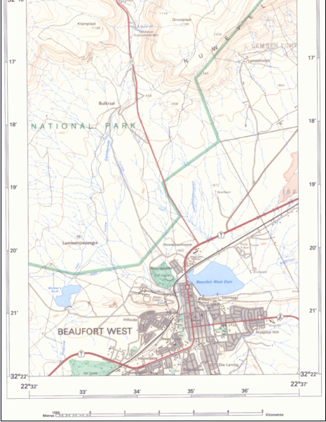
Conventional signs used on 1:50 000 maps
These signs form part of the “language” of topographic maps. They are provided in the key / reference below the map and are used the world over. You should get to know and understand them thoroughly.
Map symbols for cultural phenomena (phenomena created by people)
The signs used on maps are selected to be immediately recognisable for what they represent. Cultural phenomena that are shown are buildings, towns, power lines (in black) dams, canals (in blue) trees, plantations and fields (in green). These symbols are exaggerated on the map, because they would be too small to be represented if their actual sizes were represented.
Map symbols for natural phenomena
The most important natural phenomena are mountains, hills, valleys and plains. These phenomena, however, have to be deduced from contour lines and are not represented by specific symbols. We’ll be studying contour lines shortly.
Another important natural phenomenon shown on topographic maps is the drainage of any particular area. This is observed by examining the rivers and their tributaries, which are indicated in blue on a topographic map.
On topographic maps, perennial rivers are indicated by means of continuous blue lines, while the (seasonal) rivers of areas with low or seasonal rains are indicated with dotted lines).
The direction of the flow of a river also provides important information about the higher and lower parts of an area:
Water ALWAYS flows from high to lower places.
Tributaries flow into the main stream in the direction of the flow.
Example:
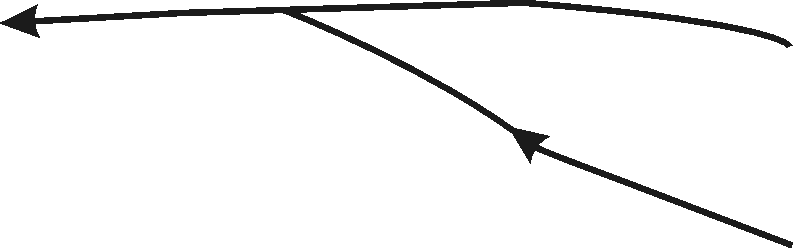
Observe the way in which dam walls are constructed across a river bed. The dam wall is always downstream.
Example:

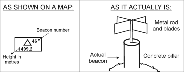
Height prediction on a topographical map
Height can be indicated on a map in several ways.
The trigonometric beacon is shown by means of a triangle with the beacon’s number to the right of the triangle, as well as its exact height above sea level, in metres, below the triangle. On a map, these beacons are usually shown to be on the highest parts.
Example:
SPOT HEIGHTS on a map are shown by means of black dots and the height value is printed alongside it.
● 1419
Example
The vertical difference in height between two high points is obtained by subtracting the lower measurement from the higher one,e.g.: A = 800 m; B = 200 m; Difference in height = 600 m.
Contour lines are unbroken brown lines marked in number values.
Contour lines connect all places that have the same height above sea level. The figure printed on the line indicates the actual height in metres.
The difference in height between two consecutive contour lines is known as the contour interval or vertical interval and is always 20 m. Each 100 m is indicated with a thicker contour line.
The further apart the contour lines are, the more level (flat) the landscape.
The closer to one another the contour lines are, the steeper and more mountainous the landscape.
Where there are perpendicular cliffs, contour lines touch. Remember, however, that contour lines never cross one another.
By examining the contours, you will be able to determine the direction in which a river is flowing and to identify certain forms of the landscape.
ACTIVITY 1:
[LO 1.4]
1. Explain what is represented by the following map symbols:
a)

b)

c)

d)

e)

2. Carefully study the area between the N1 and the R81 (SE corner of the map). Name at least six map symbols that occur in this area.
3. Are there any indications that the railway is electrified?
4. What type of communication lines join Beaufort West with the outside world?
5. What map symbols will you find at the following coordinates?
a) 32º17’06”S ; 22 37’15”E
b) 32º19’11”S ; 22 34’04”E
c) 32º20’49”S ; 22 34’09”E
d) 32º19’26”S ; 22 37’28”E
6. What is the average height above sea level in the vicinity of the rifle range(32º19’06”S ; 22º35’37”E)?
7. What is the height of the highest trig. beacon on the topographic map?
8. What is the contour interval on this map?
9. Determine the vertical difference in length between Lammertjiesleegte (32º20’52”S; 22º33’37”E) and trig. beacon 148.
10. Is there any relation between the route of the railway and the relief of the area?
11. What is the name of the perennial river in this area?
12. In which direction does this river in no. 11 flow?
13. Do you think there is a flood danger in this area? Explain.
14. What indications are there on this map that stock farming occurs in this area?
15. What do you think is the purpose of the furrows indicated on the map?
16. What can you derive from the rainfall in this area?
| Learning Outcomes(LOs) |
| LO 1 |
| Geographical EnquiryThe learner will be able to use enquiry skills to investigate geographical and environmental concepts and processes. |
| Assessment Standards(ASs) |
| We know this when the learner: |
|
|
|
|
ACTIVITY:
Built-up area. (Mgquba).
ρ 84 = 624,2.
624,2 – 540 = 84,2 metres.
Notification Switch
Would you like to follow the 'Geography grade 8' conversation and receive update notifications?

|
|
|
|

|
|

|
|

|
|

|
|
|
|

|
|

|
|

|